Guy Shrubsole with research by Chris Gordon-Smith17 Mar 2020
Friends of the Earth wants to double UK woodland cover by 20501 – to tackle the climate emergency and make more space for nature. Increasing tree cover is an essential part of a range of measures needed to fight climate change – including eating less and better meat and dairy, which itself will free up more land for trees and woodlands.
But is there really space in the UK to double tree cover? And where’s best to grow all those trees – whether through deliberate planting schemes or allowing natural regeneration?
It’s an important set of questions. Although we want to see more trees everywhere, some land isn’t ideal or appropriate for growing trees. And we might find we get multiple benefits from woodland creation if we prioritise particular locations. Friends of the Earth has been examining the issues in detail and we indicate some of the areas we think could be prioritised for new woodland creation.
Where best to grow more trees – issues and trade-offs
In finding the best land for afforestation, there are some important trade-offs to consider.
While woodland currently covers 13% of the UK, approximately 70% of the UK is farmland. It’s clear that if we’re going to double tree cover, some of this farmland will need to be converted into woodland. (Of the remaining 17%, less than 10% is urban, and the rest comprises other habitats like mountains, moorlands and wetlands which are often too high, too acidic and too wet for many trees.)
Land to feed people directly
Friends of the Earth has previously modelled possible scenarios for future land use change in our Land Use Calculator, which draws upon a wide range of academic studies. This shows that if we continue to shift our diets to eating less and better meat and dairy, we’ll be able to free up a lot of land that’s currently used for pasture, especially low-grade rough pasture and cropland that’s used for livestock feed.
We don’t want to grow lots of trees in places that are more valuable for growing food crops for direct human consumption. Doing so could reduce food production in the UK, increase food imports and drive deforestation overseas. So, we need to protect arable cropland wherever possible, and prioritise its use for growing crops for direct human consumption (rather than for biofuels or animal feed2).
We also need to avoid the further intensification of arable land (involving more pesticide and fertiliser use and reduced soil and water quality), which could result from a reduction in this land area. Intensive farming is a leading driver of biodiversity decline and the poor state of nature in the UK, and we need more farmland to be under agro-ecological management. We envisage a smaller livestock population being grazed on higher-quality, more species-rich pasture; fewer intensive pig and poultry mega-farms; and more mixed farms, where livestock is used to improve the fertility and soil carbon content of arable land.
Equally, we know that agroforestry – the planting of trees alongside crops, or as shelter for livestock – also has great potential. We’ve been exploring how agroforestry could be expanded and what that might mean for increasing tree cover whilst supporting sustainable farming.
Public benefit
Another issue we’ve been examining is where to grow trees that give the greatest public benefit. In England, 43% of neighbourhoods have less than 10% tree cover, and many people living in towns and cities today feel cut off from nature, with over four-fifths of the most-deprived neighbourhoods (those with less than 5% tree cover) situated in urban areas. Greening urban areas through more street trees, parks and community growing spaces is vital – with multiple benefits in terms of provision of shade, countering air pollution and improving people’s physical and mental health. And so is having more nature on our doorsteps on the outskirts of towns and cities.
Conflicting priorities
That is why establishing additional woodlands in close proximity to urban areas is something we’ve tried to prioritise. For this, we obviously must take account of the fact that urban edgelands are often prime locations for new housing and other developments. However, most of our large cities are surrounded by green belt land, which means that development is not permitted, unless the planning authority takes the (politically difficult) step of relaxing the green belt boundary. Green belt land ought to be a good place for expanding woodland cover.
Sometimes, however, different priorities come into conflict. For instance, a lot of towns and cities were originally established near to fertile soil, which often remains good-quality cropland. And a lot of the lowest-grade farmland, in the foothills of our upland areas, is remote from where most people live. We’ve tried to address this in our analysis by finding areas of overlap – poor-quality farmland that is close to towns. At the same time, we suggest it’s also good to be creating more woods and forests in more remote upland areas too – to provide space for nature and to help reduce flood risk downstream.
Avoiding deep peat bogs
Some soils just aren’t suitable for tree-planting. Deep peat bogs, for example, are often too acidic for most native tree species to establish themselves at high densities. Large-scale planting of conifers on peat (such as happened in the Flow Country in Scotland in the 1980s) has been shown to be damaging to peatland ecosystems and results in more soil carbon leaking out into the atmosphere, worsening climate change. That's why in our mapping we steer clear of planting trees on deep peat.
Avoiding species-rich grassland and other Priority Habitats
Nor do we want to see tree-planting damage other precious habitats, such as species-rich meadows and grasslands, the vast majority of which have been lost over the past century as a result of agricultural intensification. Remaining fragments of wildflower meadows are vulnerable to well-meaning but misguided tree planting projects, such as recently occurred in Cumbria.
To seek to avoid this in our modelling, we've used Natural England's Priority Habitats Inventory to screen out these habitats from consideration for woodland creation.
But we know that this national dataset is incomplete, particularly when it comes to species-rich grasslands. That's why we back the calls of some grassland conservationists for Natural England to produce a new Valuable Grassland Inventory, to better protect these habitats and guide future decisions about where to establish new woods.
Which tree species?
There’s also the matter of which tree species to grow. Soil type, tree diseases, latitude and local climatic conditions all make this very localised, and subject to change as the climate shifts – so we don’t go into any detail here about particular tree species.
Clearly, broadleaved native tree species are better for biodiversity than non-native conifers. A large amount of the expansion in UK forest cover over the past century has come from Forestry Commission Sitka spruce plantations, which do little for wildlife and can acidify soils.
Growing more timber for domestic use
At the same time, the UK currently imports vast quantities of wood from overseas, including from countries like China and Brazil, where opaque supply chains means UK consumers may still be unwittingly contributing to tropical deforestation. It makes sense for us to reduce our reliance on these imports and to grow more domestic timber. And if more homes and buildings were constructed with such timber, we’d be locking up more carbon for the long-term.
There’s significant room for improving forestry standards to give greater weight to biodiversity, alongside a vast expansion in native broadleaved woodland that should stand as woodland forever.
Getting support
Last, and by no means least, there are questions of acceptability to farmers, rural communities and the general public, as well as land ownership and tenure, and land values. These are all hugely important factors in determining where trees will get grown. A landowner may possess perfect quality land for planting a woodland but choose not to do so. A tenant farmer may reasonably object to planting trees on pasture that’s essential to their livelihood. A community may understandably object to the character of their local landscape being changed. The capital value of land varies across the UK, with land tending to be more expensive in the south east of England and cheapest in Wales, Scotland and Northern England.
None of what we propose here is intended to be a top-down model imposed upon others. It simply aims to show that doubling tree cover in the UK is possible and that the UK has the land available to do it, without undermining other essential land uses, and to do so in ways that can lead to multiple benefits. Obtaining support from landowners, politicians and communities is of course the next challenge.
Alongside this, it’s essential that the new system of agricultural support to farmers and landowners after Brexit properly encourages and rewards appropriate tree planting for the climate, biodiversity, and other benefits it provides.
The results of our mapping
To assess where might be best to grow more trees, we used a number of publicly-available mapping data sets and used GIS (Geographic Information Systems) software to combine and analyse them.
Below are our headline findings which demonstrate the potential to double tree cover in England. We are similarly assessing Wales, Scotland and Northern Ireland, but data sets have so far proven more difficult to find.
- England comprises 32 million acres (12.9 million hectares), of which 3.36 million acres (1.36 million hectares) is already covered with woodland – just over 10%.3
- The government’s system of Agricultural Land Grades divides the country into 5 grades of farmland quality (alongside urban areas and some non-agricultural land). Grades 1-3 are high-quality land well suited to crop growing, so while they may contain many areas available for tree planting, we’ve excluded them from consideration. We’ve also excluded Grade 5 land, as this is a good proxy for upland peat bogs.
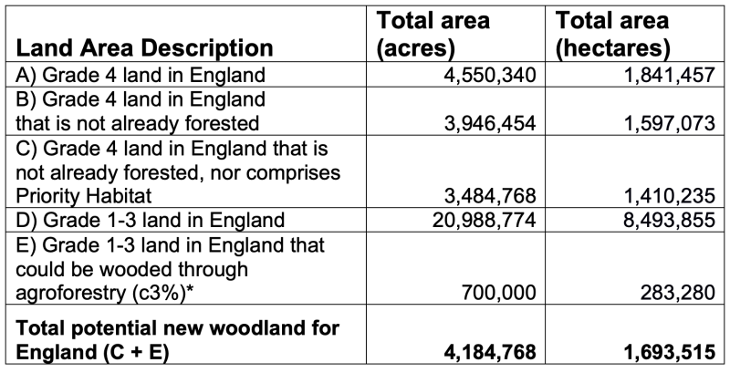
- This leaves us with 4.5 million acres (1.8 million hectares) of Grade 4 poor-quality farmland, mostly used for pasture currently. Some already has trees growing on it. The remainder covers around 3.9 million acres (1.6 million hectares, 12% of England). If we were to grow trees on all of this it would more than double England’s forest cover, taking us to 22%.
- Screening out all Priority Habitats, using Natural England's Priority Habitats Inventory, leaves us with 3.5 million acres (1.4 million hectares, 11% of England). This suggests we could still more than double England's forest cover, taking us to 21%, without impacting on any other precious habitats. Of course, as mentioned above, we also think Natural England needs to be improving its habitat records - such as by creating a new Valuable Grassland Inventory - and giving proper protections to these precious habitat fragments.
- We think there would be huge benefits in prioritising the growing of broadleaved woods on Grade 4 land that’s close to where most people live in towns and cities. We’ve overlaid a Forestry Commission map layer showing "Priority Places" surrounding urban areas – particularly the most deprived urban areas – with our map of Grade 4 land. That gives us a little over 1 million acres (around 442,000 ha) of suitable land, where we could create new broadleaved woodlands easily accessible to millions of people, and which wouldn’t have any major impact on UK food production.
- Of course, adding 1 million acres of trees to England isn’t enough – each nation needs to play its part to get the UK to the goal of doubling overall UK tree cover. So, we should consider also planting on more of that Grade 4 land in more remote places too. In such places, providing it’s done sensitively, it may be appropriate to plant conifers for fast carbon draw-down and for sustainably-managed timber – as well as deciduous woodlands on steep hillsides and valleys where timber extraction is impossible and reducing flood risk ought to be the priority.
- We think England can add further to its tree cover by ramping up support for agroforestry. This would allow for more trees to be planted on farms and has been shown to be beneficial – and not reduce food output – even on high-quality arable soils, such as in Cambridgeshire. 4 A typical agroforestry system has between 70 and 200 trees per hectare, compared with 400 trees per hectare in a typical planted wood. We’ve assumed therefore that on average, an acre of land in an agroforestry system has around a third of the tree cover of a wood. We’ve also assumed that agroforestry ends up being adopted on 10% of all land in Grades 1-3 across England, or around 2 million acres.Given our assumptions, this equates to around 700,000 acres (283,280 ha) of farmland planted with new trees.
- There's also great potential for increasing tree cover through increased use of shelterbelts and hedgerows. Increased hedgerow planting – or doubling the width of existing hedgerows and incorporating more trees – could make a significant contribution, but is outside the scope of this mapping.
- This document is not prescriptive. It's an illustrative scenario for discussion. Advocating woodland creation based on land classification can only ever be a broad-brushed approach, but allows us to consider the potential scale of afforestation. Many areas of Land Grades 1 to 3 may have parcels suitable for woodland creation at a variety of scales. Farmers and landowners know that each farm is different, and every field is different. Clearly the suitability of individual parcels of land for tree growing versus other uses should be determined by land managers and ecologists who know the characteristics of each landholding.
In summary: there is potential to double England’s tree cover, by:
- Growing trees on 3.5 million acres of poor-quality Grade 4 land - protecting valuable farmland, peat bogs and all other Priority Habitats.
- Expanding agroforestry on farms across the country, adding a further 700,000 acres of trees.
- That gives a total of 4.2 million acres – 13% of England’s land. Adding that to the 10% of England that’s already wooded gives 23% tree cover.
- Figures for hectares are also given below.
We want to repeat this mapping for Wales, Scotland and Northern Ireland, but good data for these nations is proving harder to find. We’ll update the analysis if and when we obtain the right data sets.
The table below summarises the breakdown of figures.
* As explained above, this is based on assuming that 10% of Grade 1-3 land is converted to agroforestry, which typically has a third of the tree cover of woodland, so the effective woodland increase is about 3%.
NB: To carry out some of the intersections, we had to "buffer" some of the layers, in order to overcome occasional glitches in the mapping data sets. This has had only a tiny impact on the area figures.
How we carried out the analysis
To arrive at the figures above, we carried out analysis using a number of publicly-available GIS mapping data sets on existing woodland cover, soil grades and settlement location. By intersecting these different map layers, we can see where there are areas of overlap – for instance, Grade 4 land that lies close to towns and cities; and areas which require subtraction from one another – such as Grade 4 land that already has trees growing on it, or comprises Priority Habitat.
The key datasets we used were as follows:
- The Forestry Commission’s National Forest Inventory GB 2017, in order to map and screen out existing woodland cover.
- Natural England’s Agricultural Land Grade maps, in order to screen out grades 1-3 high quality farmland. We also used the land grade 5 layer in this map as a good proxy for peatland, in order to screen that out (and sense-checked it against other peatland datasets below).5
- Natural England's Priority Habitat Inventory maps, to screen out and hence protect Priority Habitats from consideration for woodland creation, which could damage them.
- The Forestry Commission’s Priority Areas for England 2016 – to show areas where woodland creation would be of greatest amenity value to the public, because they would be close to towns and cities, and especially deprived urban areas.
We also examined a number of other datasets:
- Natural England’s Moorland Line map, available from MAGIC, which maps a very similar area of upland to that covered by the Grade 5 land in Natural England’s Agricultural Land Grade maps. We referred to this to ensure we were excluding areas of peatland from consideration for tree-planting. We're also aware that Natural England have unpublished maps that more accurately show the location of deep peat – these could be referred to in future for specific tree-planting and tree regeneration schemes.
- The government’s data on Green Belt land. Green Belt land can’t be developed for housing (not without special dispensation) and it surrounds many of England’s major cities. As such, it could be targeted for woodland creation – "greening the Green Belt". We decided to use the Forestry Commission’s Priority Areas maps as a proxy for amenity value instead, but Green Belt land covers a larger area, and might be used in preference.
- The Environment Agency’s Working With Natural Processes (WWNP) maps. These were generated by the EA to map which land might be reforested to give greater potential for flood mitigation. There are 3 datasets here of most use - WWNP Floodplain Woodland Potential, WWNP Riparian Woodland Potential, and WWNP Wider Catchment Woodland Potential. They suggest that vast swathes of England could be usefully replanted with trees for natural flood mitigation purposes.
- 1We estimate that doubling UK woodland cover could help absorb 10% of the UK’s greenhouse gas emissions annually – some 47 MtCO2e. This is based on calculations by the Royal Society (Royal Society and Royal Academy of Engineering, 2018, Greenhouse Gas Removal, https://royalsociety.org/-/media/policy/projects/greenhouse-gas-removal/royal-society-greenhouse-gas-removal-report-2018.pdf) that planting 1.2 million hectares of forest, ie taking woodland cover to 18% of the UK land surface, would deliver annual carbon sequestration of 15 MtCO2 per year. Doubling UK woodland cover (from 13% to 26%) could therefore sequester 37 MtCO2e per year. In addition, the Royal Society calculates that deployment of biochar (woody charcoal addition in soil) and greater use of wood in construction could sequester a further 10 MtCO2e annually. 47 MtCO2e is 10% of current annual UK greenhouse gas emissions of 460 MtCO2e (BEIS GHG stats 2019).
- 2Where animal feed supplements remain needed, it will be important to minimise reliance on imported crops like soybeans – whose production is contributing to deforestation and habitat destruction in South America – by growing temperate high-protein feeds like lupins and peas.
- 3Forest Research, woodland statistics, June 2018, https://www.forestresearch.gov.uk/tools-and-resources/statistics/statistics-by-topic/woodland-statistics/. Note that overall tree cover is estimated by Forest Research to be slightly higher than woodland cover, because individual trees in gardens, streets, hedgerows etc add to the overall tree canopy cover of the country: see Forest Research, Tree cover outside woodland in Great Britain, 2017,
- 4For example, Stephen Briggs’ agroforestry operations on his farm in Cambridgeshire: https://www.agricology.co.uk/field/farmer-profiles/stephen-briggs
- 5The Agricultural Land Grades dataset is described as being "Provisional". We asked Natural England why this is the case: they replied that this is because, when the surveys were done between the 1960s and 1988, there were plans to update them with more granular data over time. However, this has never been done, so this dataset remains the most up-to-date map of Agricultural Land Grades across the country. (Some more detailed surveys exist but only for small areas of land.)


